Visiting the Cypress Hills of Alberta and Saskatchewan
The Cypress Hills are located in southeastern Alberta and southwestern Saskatchewan. The two provinces share an inter-provincial park, which feature this landscape. The parks are located in the central areas of the Cypress Hills, but the geographical area itself extends quite a bit farther than the park boundaries. The parks are about 30 miles east-west and about 10 miles north-south. The higher elevation area is probably more like 100 miles by 30 miles, depending on how you define “higher elevation”.
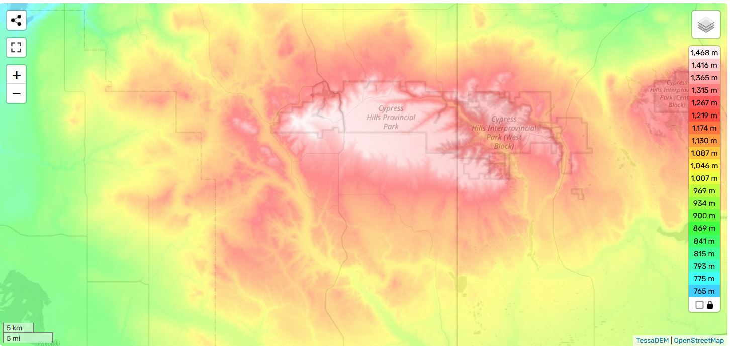
The hills are a geological and geographical oddity, as they arise rather suddenly from the mostly tabletop prairie that surrounds them. They are fairly extensive in area, so not just a small anomaly. At their highest peak, they rise to 4810 feet on the Alberta side and 4567 feet on the Saskatchewan side. The surrounding prairie tends to be at around 2000 to 2500 feet or so, so that’s a fairly substantial increase in elevation.
A plaque in the park calls the Cypress Hills “an island in the ice”. This refers to the fact that the area’s height saved it from being covered by the massive sheets of ice that blanketed much of the northern half of North America in the recent past (recent by geological standard, some 10,000 or so years ago).
As with any island, that created a habitat for plants and animals that is quite different from the surrounding area. In fact, the flora and fauna tends to be quite similar to that found in the more mountainous areas to the southwest, in Montana and Wyoming. For animals, that includes a lot of smaller animals (rodents, rabbits, skunks, weasels, foxes, lynx) as well as some larger mammals (elk, deer, pronghorn, coyotes, cougars). As an example, attached is a picture of a deer that was keeping watch on us, during our hike through the trees.

As for plants, the dominant trees are aspen, lodgepole pine, and white spruce. The grasslands are mixed-grass prairie and fescue prairie in higher elevations. There is an abundance of wild flowers. Elkwater Lake, which is within the park boundary has many species of fish, including walleye, perch, pike and trout.
There is a small town in the park, Elkwater, which caters to park visitors. There are some hotels and cabins for rent, some restaurants, pubs and other shopping opportunities. The town is on the shore of Elkwater Lake, which is used for various recreational activities. My traveling companion and I rented one of these cabins for a couple of nights. It was pleasant and a bit quaint. It had a shower. That’s always nice. We used it as a base camp for exploration for a couple of days, then tented it for a night in one of the rather nice campgrounds farther into the interior of the park. Our explorations involved some driving, some hiking, some sight-seeing and a visit to a historical recreation of a former Northwest Mounted Police fort.

On the first day, we drove the loop from Elkwater eastward along Reesor Lake Road, then south along Battle Creek Road and back west along Graburn Road. This is all in the Alberta side of the park. That took about one morning, what with various stops along the roadways to check out the viewpoints and the plaques and do a bit of hiking. Driving in a counter-clockwise direction from Elkwater, here are some of the features along the way:
-
The Reesor Viewpoint, along Reesor Lake Road. A nice little spot with great views of the valley and river beyond. There is a picnic table and a plaque about the aforementioned “island in the ice”.
-
Police Point Slump (and plaque), along Battle Creek Road. In 1967 there was an enormous “slump” (a sort of landslide) of rock and soil at this point. A rapid snow-melt in the spring of that year caused a lot of seepage into the pore spaces of the conglomerate rock below (a sort of natural concrete). The base of the hills was composed of bentonite clay (very slippery, used in oil drilling) so the weight of the waterlogged soil and bedrock was too much, and thus a sudden slump of several million cubic meters of earth was the result. A lot of the vegetation has grown back since then, but there is still evidence of the slump today, though it was a lot less dramatic than in the past, at least to my eyes. There is apparently a biking/hiking trail along the ridge, which probably gives better views than the roadside pullout does.

-
The Graburn Overlook, along Battle Creek Road. This is a pretty little spot with another plaque. It points out that this is one of those “continental divide” locations, where water in one creek flows south and eventually joins up with the Mississippi River system, thus flowing to the Gulf of Mexico, while water from a nearby creek will flow north and eventually end up in Hudson’s Bay. During the 1930s the “flats” hosted a picnic and rodeo, which attracted people from all around. The name Battle Creek is a reference to an event that occurred somewhat downstream, known as the Battle Creek Massacre (more on that later).

-
The Graburn Cairn, at the start of Graburn Road. This is a cairn that was put up quite some time ago, by the looks of it, by the Province of Alberta. It commemorates a NWMP constable named Marmaduke Graburn, who was shot and killed in the Cypress Hills in 1879. He was the first officer to be killed by violence (as opposed to an accident or similar misadventure) after the force was constituted in 1873. A Blood Indian by the name of Star Child was accused of the murder but was found not guilty in 1881. Apparently, he and Graburn had been seen having an argument earlier in the day that the officer was killed, but the jury found that too weak a case to convict. There is also a large roadside marker on the Trans-Canada Highway that commemorates this officer. He was just 19 and his main duties involved looking after some of the horses that the force used (it was, after all, the Northwest Mounted Police).
-
The Survival Tree, along Graburn Road. This plaque and lookout is devoted to a very old tree, a lodgepole pine that has become celebrated as “The Survival Tree”. According to the plaque, it has endured “wind... heavy snows and... summer drought” as well as “mauling by cattle”. It is over 125 years old, as it was known to have been cut down in 1900, but has regrown since then. It’s kind of gnarly and not too tall, but it’s a fighter. So, make like my hiking partner and give it a three cheers.

-
Bull Trail. This gravel road intersects the loop in a couple of spots. And, yes, there were cattle on the road, though we didn’t check to see if any of them were bulls.


I should note that you can take Bull Trail south to a road that’s outside of the park boundary (Fox Road, which turns into Township Road 24) and loop back to Highway 41 or some other local roads. Alternatively, you can go north on Bull Trail, to get to a campground and small lake (Spruce Coulee).

After having lunch in town we headed out to Horseshoe Canyon lookout, for a short hike (about an hour), took the view and got some pictures. A friendly stranger offered to take some photos of us, which we appreciated. It was a hot day, and some of us were looking pretty scruffy by then. After that, we went back to town to wander around the lakeside for a while and just relax. But, like MacArthur in the Philippines, we said “we shall return”.

Which we did, the next day, for a longer looping hike along the Old Baldy and Horseshoe Canyon trail, up to Horseshoe Canyon, then back through the Beaver Creek trail, which went through the forest along Beaver Creek. Lake Elkwater is at 1230 meters elevation and Horseshoe Canyon is at 1450 meters, so it is a climb of about 220 meters (about 730 feet), and the trails involved come to about 5 km in length. So, that’s an average grade of about 5%, which is a pretty good workout. That said, a lot of the walking is along flat stretches, especially the hike along Beaver Creek.

There was quite a profusion of wild flowers to be seen, several lookouts with spectacular views and some sections with stands of tall trees. My hiking partner spent some time corresponding with a curious squirrel and we also saw some deer along the way, through the trees.


That hike took most of the afternoon. We then struck out for a campground, to spend at least on night in our tents. I believe it was the Spruce Coulee campground, though it might have been a different one. Regardless, it was a fairly big “car camping” campground with plenty of campers. It was quite well supplied with the usual amenities – pit toilets, water, firewood, etc.. I vaguely remember a shower, but I can’t be sure of that. It was fairly quiet for a well-attended camp.
The next day we headed for the Saskatchewan side of the park. The weather had been quite dry, so the roads within the park were very good.

The Saskatchewan side of the park has fewer campgrounds and view points, but it does have a few very notable attractions. One of these is the Conglomerate Cliffs, which are reached by continuing along the Battle Creek Road east, then taking Ranger Station Road and Conglomerate Cliffs Road. Eventually you arrive at a rather spectacular viewpoint, which looks across the hills, to the badlands across the river and the prairies in the far distance.
The unique feature of the Conglomerate Cliffs is, of course, the conglomerates. As noted previously, this is a type of rock that is often referred to as “natural concrete”, whereby gravel is intermixed in a matrix of sand and cement, usually of calcite or quartz, which binds the rock together. So, it does rather resemble the concrete you might use for a sidewalk. In these cliffs the “clasts” (cobbles or just plain rocks in more common parlance) are generally of a light brown hue, made from eroded sedimentary rock such as sandstone. The hard conglomerate capstone is relatively resistant to erosion, so the cliffs can be somewhat undercut, and jut out from the underlying rock formations. As you can see in the photo, this can result in some unusual looking cliffs, and it’s a fair ways down, so one is advised to be careful while scrambling about.

After spending some time at these cliffs, we headed to the other notable attraction, nearby Fort Walsh, a historical reconstruction of an early Northwest Mounted Police fort.
Fort Walsh was built in the early days of the NWMP. In June 1873 there was an armed conflict between American “wolf hunters” and the native Nakoda people, at a site just south of Fort Walsh. This has become known as the Cypress Hills Massacre, as many natives were killed. That pushed the new Canadian federal government (Canada was constituted in 1867) into creating a police force to enforce the law in the Canadian prairies. By June 1875 Fort Walsh had been constructed and manned by the Mounties.

By way of background, the fur trade was still a going concern through most of the region, but unscrupulous traders, mainly but not exclusively from the U.S., were including liquor (often cut with even more unhealthy substances) among the trade goods, which was causing great distress to the natives, who had little experience with the stuff. That was one of the primary reasons that the Mounties were created, though patrolling the border was also important, as was bringing Canadian law to the unregulated west, in general. Events in the U.S., particularly the Battle of the Little Big Horn, also had their repercussions in Canada, including the migration of some of the natives involved in that conflict. So, Fort Walsh and its personnel became involved in negotiations among American authorities and the Lakota.
So, Fort Walsh was an important outpost in the early days of Canada’s development of the west. The reconstructed fort and native encampment, along with the historical actors employed there, are set in that era. The fort is supplied with goods and equipment that fit the times, as are the employees, who are dressed as Mounties or support staff who might have been employed at the time. That equipment includes a cannon (maybe two), though I can't recall for sure. There are some occasions when the cannons are fired, with charges but no projectile, but this was not one of those days.
The actors discuss “their” lives, at they would have lived them at the time. That would include what they ate, where they slept, how they maintained horses, what weapons they had, what they did in their off-hours and so on. This proved to be very interesting.
On a personal note, one of the items that was on display was a “crokinole board”. This was a sort of shuffleboard or curling game, reduced to tabletop dimensions. Rather than slide a rock down the ice, the player flicks a disk towards a series of concentric rings, rather like a curling rink. In my youth, one of my friends had such a board, and we all played this game quite often. It was interesting to see that it extended back that far in time. Wiki says printed references to the game in Canada go back to 1867, while the earliest American references were from 1880. Obviously, though, it must have been invented before these references. At any rate, it was an amusing walk down memory lane for myself and my hiking partner.

With that, we had to wrap up our short but interesting trip to the Cypress Hills and head back on the long drive to Edmonton.
And here are some travel accounts that you might like, on Amazon.
===========================================================
On the Road with Bronco Billy

Sit back and go on a ten day trucking trip in a big rig, through western North America, from Alberta to Texas, and back again. Explore the countryside, learn some trucking lingo, and observe the shifting cultural norms across this great continent.
Amazon U.S.: http://www.amazon.com/gp/product/B00X2IRHSK
Amazon U.K.: http://www.amazon.co.uk/gp/product/B00X2IRHSK
Amazon Germany: http://www.amazon.de/gp/product/B00X2IRHSK
Amazon Canada: http://www.amazon.ca/gp/product/B00X2IRHSK
=======================================================
What follows is an account of a ten day journey through western North America during a working trip, delivering lumber from Edmonton Alberta to Dallas Texas, and returning with oilfield equipment. The writer had the opportunity to accompany a friend who is a professional truck driver, which he eagerly accepted. He works as a statistician for the University of Alberta, and therefore is generally confined to desk, chair, and computer. The chance to see the world from the cab of a truck, and be immersed in the truck driving culture was intriguing. In early May 1997 they hit the road.
Some time has passed since this journal
was written and many things have changed since the late 1990’s.
That renders the journey as not just a geographical one, but also a
historical account, which I think only increases its interest.
We
were fortunate to have an eventful trip - a mechanical breakdown, a
near miss from a tornado, and a large-scale flood were among these
events. But even without these turns of fate, the drama of the
landscape, the close-up view of the trucking lifestyle, and the
opportunity to observe the cultural habits of a wide swath of western
North America would have been sufficient to fill up an interesting
journal.
The travelogue is about 20,000 words, about 60
to 90 minutes of reading, at typical reading speeds.
==========================================
Driving North - On the Road to Northern Alberta and the Northwest Territories: A Driving Journal

Have you ever wondered about a road trip to the far north, north of the Sixtieth Parallel? Well, here is your chance to read about three road trips, through the Peace River country and the northern Rockies, all the way to the shores of Great Slave Lake, just south of the Arctic Circle.
Just $1.99 on Amazon, or free if you have Kindle Unlimited.
Amazon U.S.: https://www.amazon.com/dp/B074LZDQ9F
Amazon U.K: https://www.amazon.co.uk/dp/B074LZDQ9F
Amazon CA: https://www.amazon.ca/dp/B074LZDQ9F
Amazon Germany: https://www.amazon.de/dp/B074LZDQ9F
Amazon Japan: https://www.amazon.co.jp/dp/B074LZDQ9F
Amazon India: https://www.amazon.in/dp/B074LZDQ9F
Amazon Australia: https://www.amazon.com.au/dp/B074LZDQ9F
The highways in northern Alberta and the Northwest Territories give one the opportunity to drive pretty far north, without a lot of elaborate preparations and extreme expense. Starting from Edmonton, one can drive as far north as Yellowknife, NWT, without leaving the hardtop, so an average vehicle can do the trip. There are a reasonable number of fair sized towns along the way, so accommodations are not much of a problem, either. The same goes for food, gasoline and other essentials.
One can also link up with the Alaska Highway, and the Dempster Highway, and make it all the way to the Arctic Ocean. But that’s another story.
Trip number 1 involved driving north through Alberta, visiting several areas of interest along the way, then into the Northwest Territories, to Hay River on the southern shore of Great Slave Lake. The return trip featured a drive through the north-central foothills of the Rocky Mountains.
Trip number 2 was a combined air and car trip. We went to Yellowknife, Northwest Territories by airplane, then rented a car to explore much of the area of the north shore of Great Slave Lake.
Trip number 3 was a return to Hay River, with a different travelling companion. This allowed one to retrace steps, compare and contrast, and focus on some areas that we had not had time to explore in depth on trip number 1.