Another Trip Through Alberta History – The Victoria Trail
The Victoria Trail in northwestern Alberta was part of the Carleton Trail, the route from Winnipeg to Edmonton during the 19th century. This route utilized some of the original trails of aboriginal peoples and also incorporated new developments. In the earliest days it was part of the fur trade route, bringing supplies into and taking furs out of the lucrative areas of what is now the Canadian west, either by river or by Red River Cart. Later it became an essential route for settlers as they developed homesteads and communities. This ranged from the early Metis and British/French to later immigrant waves, notably the Ukrainians.

Part of the trail (about 60 km) is still in use, in an area northeast of Edmonton. It still has the “narrow river lot” land system, which is unusual in most of Canada outside of Quebec. This relates to its early settlement by Metis people, who preferred this arrangement to the squared-off Township system that was primarily utilized in the Canadian west, since this gave everyone in the area an outlet to the North Saskatchewan River, which was also a very important travel route.
The pattern of settlement began with a fur trading fort, then later various communities sprung up along the trail. There is a partially reconstructed historical fort (a number of buildings, at least one of which is original, along with some partial palisades), as well as the evidence of some of the older communities, consisting of residences, churches and cemeteries. The area is still being farmed, so there are also many people living in the region. Cultivated fields and farm animals are a regular sight, while touring. There are also some pretty views of the North Saskatchewan River, which is one of the longest rivers in Canada.
This travel blog is an account of a trip to the Victoria Trail and some touring of the area in May 2023, of myself and my son. Basically this was a one-day road trip (about 10 hours in all) from Edmonton, Alberta. However it could easily have been stretched out into a longer trip, as there is much to see and several communities where one could stay for a night or two. That includes the development known as Metis Crossing, which is actually on the western end of the Victoria Trail.
Getting to the Victoria Trail, from Edmonton
Edmonton to Rochester, Hwy 2. Then from Rochester to just past Newbrook, highway 661
My son and I shared the driving on this leg of the journey. That was to give him some extra time behind the wheel, as his university studies (PhD at McGill in Montreal) had interfered with the driving experience (i.e. time and money). He was a little rusty, but picked it up nicely.

We took Highway 2 from Edmonton, turning off near a community called Rochester. Highway 2 north of Edmonton is a relatively moderately-trafficked highway, once one has gotten a reasonable distance away from the city. Rochester was a little place, rather quaint and pleasant looking, with some businesses open, but no gas station as far as we could tell.
Secondary highway 661 was two-lanes, with narrow shoulders, but was in good shape. There was very little traffic at the time we were on it, so it was a pleasant drive. There were some rather winding intervals, featuring some hills, and valleys of waterways. It was quite attractive country, especially around Rochester.
Turn south at intersection of 661 and 831, near Newbrook
Newbrook is also small and quaint. There was a sign for Newbrook Historical Society Space Observatory. Might be interesting to check out some day. (I have a couple of telescopes and Scott has a PhD in astrophysics). Wiki informs us that it was built by Stellar Physics Division of the Dominion Observatory, operating from 1952 to 1957. One of the scientists working there took the first picture of Sputnik 1, the first artificial satellite. Apparently, the historical society has reconditioned this original camera.
This highway (831) was fairly straight and smooth. We passed by an alpaca or lama farm. They are amusing looking animals and apparently very docile. I can recall seeing ads for these on late night TV (i.e. they would sell you the materials to run your own alpaca farm). I believe that the market got overcrowded, so as a business proposition, it was not always so great. But alpacas are supposed to be easy animals to care for, so they still make nice hobby farms for people with time and money. Their wool is extremely soft, so it fetches a good price.
At one point, there seemed to be some oilfield type traffic. Among other things, some large ATCO trailers were being taken somewhere, probably to a rig-site. These trailers make job-office sites as well as living quarters. They were fairly wide loads for a 2-lane highway, but Scott managed it just fine.
There was also a big grain elevator, or that’s what I assumed it was. There may also have been a small rural airport along this route.
Turn east at Waskatenau, onto Highway 28
Waskatenau is actually somewhat off the highway, so we didn’t get much chance to see it.
This highway (28) has wider shoulders, as would be assumed by the numbering (roads with 2 digit designations are generally wider and have more traffic).
Turn south at Smoky Lake, onto Highway 855
We noted an entry point for the Iron Horse Trail, while driving through Smoky Lake. This is a hiking, cycling, snowmobiling trail, that now goes for a long way in north-central Alberta. It was originally a railroad line, but that was taken out and the road-bed was converted to these recreational uses. I have biked a section of the Iron Horse a couple of times, years ago, though not through Smoky Lake, as the trail hadn’t yet reached this area, at that time. It would be interesting to explore the enhanced trail some more.
The sign for Highway 855 is a bit small and easy to miss. The road is also called 50 Street within Smoky Lake (which is a fair-sized place).
Turn onto Victoria Trail, about half-way between Smokey Lake and the intersection of 855 and 45
The Victoria Trail (historic) is on both the east and west sides of Highway 855.
To the eastern side, there is the Metis Crossing development, a rather elaborate tourist and cultural centre.
This development includes a motel, campground, and geodesic domes. The latter are sky-watching domes, which sound pretty cool. You can watch the night-sky from within, and if you are lucky there might be Northern Lights (opening Jun 1, 2023). In addition, their website highlights many cultural activities, celebrating the Metis way of life.

This is worth looking into, for a multi-day trip, rather than just a day trip, as Scott and I were embarked upon.
The photo below is from their website (promotional), the photo above from our trip. As you can see these domes were currently under construction, but I think this is a terrific idea (and they are not paying me to say this, though I think that would be a terrific idea too).

Beyond that is the Victoria Tail National Historic Site.
This has a small parking lot, a picnic table, an outhouse
facility, and a large collection of plaques, sandstone markers and
flagpoles, with information about the historical significance of the
area. By the way, that's my son Scott in the photo.

It had a nice picnic spot, where Scott and I ate our lunch, which was composed of sandwich makings (buns, sausage, cheese, butter), cucumber slices, apple slices and coffee and/or juice. Thankfully, there were very few annoying insects about (none, really). This had been a hot and dry spring so far.

Down a ways, from the flag-stand, one could see the North Saskatchewan River. This is the large river that became a gateway to the Canadian Northwest, via canoe and York Boat. For this section of the Victoria Trail, one is never far from the river.
Across the Victoria Trail road was an interesting cemetery, with many old grave markers.
It was up a fairly high hill, so it provided a fairly good workout to get there. The road up there was quite steep, probably a car could do it, but we thought it best not to try.

The area at the top also had a bison ranch, though there were no bison in evidence at the time of our visit (around lunch hour).
Some of the graves went back to the 1800s. Most were old, some were unreadable. Any wooden markers had long since withered away. At least one grave had a sort of small angel, which had a small solar panel. One assumes that it must light up at night.

On the way back down the hill, we noticed a plethora of little dirt mounds, with a hole in their center. We thought perhaps this was the result of some sort of wasps or similar insects that nested in the ground (digger wasps seem like possibility). There were also other suggestions (noted later).

Then, we carried on the east side of Victoria Trail to the Victoria Trail Historical Site.
I believe this also has both provincial and federal government support. It certainly conforms to many of the federal government’s programs, given the multi-cultural aspects of its Indigenous, Metis, French/British and Ukrainian history. Many plaques and signs have been put up, giving details of the history of the site and the general area. There were a few other visitors, but not many, as it was so early in the season.
The site holds a group of buildings, some original and perhaps some reconstructed. In particular, the Clerk’s Building (Hudson’s Bay employee at the time) is the oldest building in the province, that is still on its original site.
There are some other buildings – school or church? There is also a residence for park staff built in the original style. I am not certain, but it might have been modeled on a teacherage, that existed at one point).
In addition, there are remnants (or partial reconstructions) of the palisade, made of log construction, showing the dimensions of the original fort. These partial walls have been placed at the location of the four corners of the original fort. There is also a path to the old ferry landing, on North Saskatchewan River.
We chatted with two women who were employees. They were just setting up for the new season, which would begin on or about the Victoria Day long weekend, most appropriately, given the name of the area. Normally they would be in costume, but today they were in ‘civilian dress’, as the settlement was just being prepared for the opening on that day.

They were very pleasant and helpful, explaining about the fort and the area. They noted the local preference for river-lots, rather than township land division. The younger lady pointed out the approximate dimensions of a river-lot (‘from about that line of trees to the group farther down, past that copse of trees’). Looking at it that way, the lots didn’t seem all that narrow.
I mentioned that it would be nice to bring Ontario visitors for a visit, day-trip or a short stay at Metis Landing. They encouraged me to do just that, saying that they would love to see out-of-town visitors, and by that time they would be in costume.
We discussed various other things, including the mysterious ‘little mounds’. One of the ladies thought they might be due to moles. That brought up stories of moles and mice, including a story of mine, in which we had caught a mouse in a live trap, but it was so quiet that it gave absolutely no indication that it was in the trap, and thus died there.
That brought on a story by one of the ladies, whereby her daughter had hidden a mouse in a chest of drawers, as she was very fond of mice. This resulted in a drawer-full of baby mice. This happened when the daughter was a child, but the lady said that the daughter hadn’t changed much since then, when it came to mice, as she is also a proponent of live-trapping.
After this nice chat, we bid them adieu, and looked around some more, then headed to the western side of the trail, across highway 855.
We then, crossed Highway 855 to tour the western side of the Victoria Trail.
There a quite a number of buildings on this side that go back to the earlier eras of settlement.
We relied upon a very useful document provided by the Alberta government document called “Historical Walking and Driving Tours: Victoria and the Victoria Trail”. It includes text and pictures of many notable historic features along the way, as well as maps of the trail (a walking map of the east side and a driving map of the west side). It can be downloaded as a pdf.
A copy of the driving map is provided below, for convenient reference:

This document is a bit out of date (copyright 2003), but still very useful. However, some plaques and roadside markers have been added since that time, so they won’t be included in the pamphlet. In addition, a few of the structures noted in the document seem to have disappeared, probably due to ongoing decay and dissolution (though in some cases, we might just have missed them).
The numbered signs that the document refers to as being along the route are not always there, or are difficult to read. However, those that remain have a distinctive light blue colouring, which is a handy verification that you are on the trail. This is helpful, as the current trail sometimes deviates from the old path, on to range and township roads, which can be a bit confusing at times. So, it is best to keep a sharp lookout while touring. Since these are lightly-travelled gravel roads, you won’t be going very fast, anyway.
Below are some notes about this part of the trip as well as some photos. I won’t repeat all of the sites mentioned in the brochure – you can get that from the internet for further details. The numbering does correspond with the numbering in the pamphlet.
We didn’t stop at all of these locations, but did stop at quite a few of them, to take some photos and read the signage. In addition, we stopped at some new sites, not included in the brochure.
(9) Whitford House:
This building is the last remaining Metis house that was built at the Lobstick Settlement (a lobstick was a sort of marker tree, that could be used as a landmark) that still remains on its original site. It is well over 100 years old, perhaps as much as 150 years old. It is still in remarkable shape – you can look through the windows and still see the layout of the rooms.
The photo below was altered a bit (pushed the brightness and contrast) in order to bring out the details of the house. Unfortunately, that washes out the blue sky and makes the grass a funny shade of green.

Nearby is a similarly old barn that is also in excellent shape; in fact it appears to have had a zinc roof added recently, so someone must want to keep it in good working order.

NWMP Monument and Plaque
This marker to the journey of the Northwest Mounted Police, in 1874, must be relatively new, as it isn’t listed on the pamphlet. However it is very notable now, along the trail. As the plaque states, what is now the relatively bucolic Victoria Trail was once the most arduous section of the trek to Fort Edmonton.

The intrepid policemen had quite a trip. And here is the monument in its full monumental glory, flags and all:

Warspite Ferry Crossing
Somewhat further down the trail is another recent marker, this one commemorating the location of a ferry crossing, that was used to cross the North Saskatchewan River, before the Waskatenau Bridge was built, in 1963. The site also features several information plaques, which reproduce the rules of ferry crossing at that time. There aren’t many ferries left in Alberta; I have used one near Peace River a couple of times, but I am not sure it is hasn’t been replaced by a bridge by now (once a certain level of traffic is achieved, a bridge is generally cheaper).

Red River Cart Statue and Plaque
The Red River Cart was used extensively for many years in the Canadian Northwest, initially as a goods carrier for the fur trade, and eventually by settlers, including Metis.

Simple in design, they were extremely sturdy and could take a lot of punishment. They could also be floated for short distances, to help get over water obstacles. Often, many of these were used in convoy fashion, known as a cart train. They might be pulled by a variety of animals, but oxen were common. It is said that they made a hell of a racket. In time, they were supplanted by powered trains and motor cars.
(10) Holy Transformation Church
Churches were extremely important for the development of communities, so there are often many different churches in a smallish area. This particular church was originally an Anglican church, but ultimately became a Russo Greek Orthodox church. It is still used on occasion and is well kept-up, as you can plainly see.

(14) Protection of the Blessed Virgin Mary Church
This very distinct church was an important structure in the town of Eldorena, which was a small community along the Victoria Trail. It has the “onion dome” style common to many Ukrainian churches, with a large central dome and four smaller domes at the cardinal points.

This church is a very good landmark on this part of the trail, as it is so distinctive.
Around this point in the trail, we got stuck behind a slow-moving farm vehicle. But, it did turn off after a while. This is a fact of life on the back-roads. It is best to remain calm about it and just enjoy the scenery while you follow the tractor.
(18) Toronchuk Farm
As you can discern from the name, a Ukrainian family from Toronto homesteaded here. I jest, they weren’t from Toronto, but they were Ukrainian. This was built in a style that was reminiscent of what had been used in Europe, with hipped roofs and plastered log walls. When the pamphlet was written, this structure was still in rather good shape, but, as you can see, the ensuing years have not been kind to it.
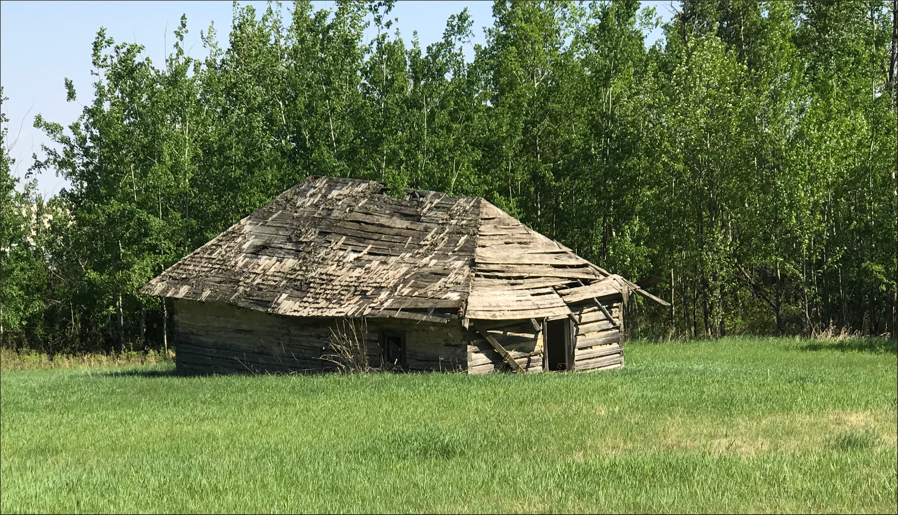
I should note that just before you get to this building (or perhaps it is best to say former building), you go over a bridge that crosses a creek.
After the Victoria Trail
Just after the aforementioned forlorn building, you arrive at the intersection of Victoria Trail with Highway 45. This is also close to Highway 830 and Highway 38. Any of these roads can be used to connect back to Edmonton, or wherever you may wish to go next.
In our case, that meant:
Highway 45 to Andrew,
Followed by Highway 855 to Mundare,
and finally Highway 16 back to Edmonton.
And here are some other travel accounts that you might like, on Amazon.
===========================================================
On the Road with Bronco Billy

Sit back and go on a ten day trucking trip in a big rig, through western North America, from Alberta to Texas, and back again. Explore the countryside, learn some trucking lingo, and observe the shifting cultural norms across this great continent.
Amazon U.S.: http://www.amazon.com/gp/product/B00X2IRHSK
Amazon U.K.: http://www.amazon.co.uk/gp/product/B00X2IRHSK
Amazon Germany: http://www.amazon.de/gp/product/B00X2IRHSK
Amazon Canada: http://www.amazon.ca/gp/product/B00X2IRHSK
=======================================================
What follows is an account of a ten day journey through western North America during a working trip, delivering lumber from Edmonton Alberta to Dallas Texas, and returning with oilfield equipment. The writer had the opportunity to accompany a friend who is a professional truck driver, which he eagerly accepted. He works as a statistician for the University of Alberta, and therefore is generally confined to desk, chair, and computer. The chance to see the world from the cab of a truck, and be immersed in the truck driving culture was intriguing. In early May 1997 they hit the road.
Some time has passed since this journal
was written and many things have changed since the late 1990’s.
That renders the journey as not just a geographical one, but also a
historical account, which I think only increases its interest.
We
were fortunate to have an eventful trip - a mechanical breakdown, a
near miss from a tornado, and a large-scale flood were among these
events. But even without these turns of fate, the drama of the
landscape, the close-up view of the trucking lifestyle, and the
opportunity to observe the cultural habits of a wide swath of western
North America would have been sufficient to fill up an interesting
journal.
The travelogue is about 20,000 words, about 60
to 90 minutes of reading, at typical reading speeds.
==========================================
Driving North - On the Road to Northern Alberta and the Northwest Territories: A Driving Journal

Have you ever wondered about a road trip to the far north, north of the Sixtieth Parallel? Well, here is your chance to read about three road trips, through the Peace River country and the northern Rockies, all the way to the shores of Great Slave Lake, just south of the Arctic Circle.
Just $1.99 on Amazon, or free if you have Kindle Unlimited.
Amazon U.S.: https://www.amazon.com/dp/B074LZDQ9F
Amazon U.K: https://www.amazon.co.uk/dp/B074LZDQ9F
Amazon CA: https://www.amazon.ca/dp/B074LZDQ9F
Amazon Germany: https://www.amazon.de/dp/B074LZDQ9F
Amazon Japan: https://www.amazon.co.jp/dp/B074LZDQ9F
Amazon India: https://www.amazon.in/dp/B074LZDQ9F
Amazon Australia: https://www.amazon.com.au/dp/B074LZDQ9F
The highways in northern Alberta and the Northwest Territories give one the opportunity to drive pretty far north, without a lot of elaborate preparations and extreme expense. Starting from Edmonton, one can drive as far north as Yellowknife, NWT, without leaving the hardtop, so an average vehicle can do the trip. There are a reasonable number of fair sized towns along the way, so accommodations are not much of a problem, either. The same goes for food, gasoline and other essentials.
One can also link up with the Alaska Highway, and the Dempster Highway, and make it all the way to the Arctic Ocean. But that’s another story.
Trip number 1 involved driving north through Alberta, visiting several areas of interest along the way, then into the Northwest Territories, to Hay River on the southern shore of Great Slave Lake. The return trip featured a drive through the north-central foothills of the Rocky Mountains.
Trip number 2 was a combined air and car trip. We went to Yellowknife, Northwest Territories by airplane, then rented a car to explore much of the area of the north shore of Great Slave Lake.
Trip number 3 was a return to Hay River, with a different travelling companion. This allowed one to retrace steps, compare and contrast, and focus on some areas that we had not had time to explore in depth on trip number 1.


