Showing posts with label cycling. Show all posts

Friday, 27 March 2026

Race Track Diary, Entry Number 20 – Billy Budd’s (Jan 16, 2026)


Race Track Diary, Entry Number

 Twenty

20 – Billy Budd’s (Jan 16, 2026)

Introduction

This blog and some following blogs are sections from an informal diary of “visits to the race-track” at a particular time and place, by a person who has followed the races with varying levels of participation over a long period. These relate primarily to some visits to the track and/or off-track betting venues in the 2025 period and onward. They contain observations about the activity, both specific and general. Although these remarks are personal, they also reflect general cultural and historical trends, as they have impacted horse-racing, wagering and culture in general.

The setting is Edmonton, Alberta, Canada (population of about one million plus). However, I imagine that the observations would apply to many places in the world, as they are a reflection of how changing trends in technology, globalization and culture in general have affected this ancient and honourable activity of horse-racing.

For now, I will use what I call “polished point-form” for the narrative.

======================================================================

  • 20 – Billy Budd’s (Jan 16, 2026)


    • We ended up skipping a week, as my brother Craig had some other appointments to deal with and my son Scott was back to work, after taking some time off during the Christmas season. But it was back to Budd’s for a Friday session of thoroughbreds at Santa Anita and bucket-pullers at Woodbine/Mohawk.

    • They must have a pretty good lunch special on Fridays at this place, as there has usually been a fairly decent ‘crowd’ at the horse-betting part of the tavern on these days. Today there were about a dozen people watching, mostly older gentlemen.

    • We got there in time for the races at Santa Anita. I like this track, or perhaps it likes me. Looking back on these diaries, I perceive that I have made money or broke even on five occasions at Santa Anita and I don’t see any money-losing days there. However, there are a few outings where I didn’t bother recording the track that I was betting at.

    • We were shut-out for the first race. That was just as well, as the winner was not the highest rated horse in the race, by my figures (though close).

    • In the second race, my preferred horse wasn’t even close. The win and place horses were both short-priced, anyway. The winner paid 2.80/2.10/2.10, so not a bet that could make you money in the long run.

    • The third race was similar, with my horse not in the money. The winner did pay a good price, however, and had the highest speed ratings by my system, though lower Beyers numbers. The same was true of the horse that came in second. So, I should have had an exactor there, had I stuck with my system. Well, that’s easy to say once the race has been run and you pour through your handicapping –"aha!, I actually had that one (though I didn’t bet on it)".

    • One of the fellows playing the horses was a true gentleman, as Craig had forgotten to retrieve one of his vouchers from the machine after the third race, due to having to struggle with that machine’s poor paper-cutting. The fellow asked us if we had left a voucher in the machine, as he was the next person to use that machine, and had found the voucher. Craig said he did forget the voucher (he had already mentioned it to me) and the fellow gave it to him. It wasn’t a lot of money (a bit over ten bucks), but it showed a lot of class on this fellow’s part. I hope the racing gods rewarded him appropriately later, with a nice win. But they are fickle gods, so I wouldn’t count on it.

    • I was shut-out again, for the fourth race. Once more, I was lucky, as my preferred horse was nowhere near the money. These were some of the best bets of the day!

    • The fifth race was on the turf (grass). Andy Beyers says that turf races don’t handicap well, as far as speed handicapping goes. This race supported his observation, as my pick ended up out of the money.

    • About this time, a group of older guys near us had a very long discussion about the merits of laser eye surgery. One of the waitresses joined in the debate. They were all very knowledgeable, having had the surgery themselves, or having had someone close to them have it. The consensus was that it worked quite well, but the prices were high and unpredictable. The things you learn at the races.

    • By that point, things were getting kind of grim. Half a card was over, and still no wins. But the 6th race had a very obvious choice, with speed numbers far exceeding the rest of the field. For some reason that I couldn’t fathom, the crowd was laying off this horse, which meant it had amazingly good odds at post-time. That threw me a bit, so I jammed out and bet it to place. It did indeed win, paying a very healthy $21.20 to win and $7.00 to place. That was enough to cover my losses for the day, though it would have been nice to cash a 11 to 1 win ticket.

    • With that winning bet, I allowed myself a beer, Rickards Red. Craig had one as well. We chatted a bit more than we did during the other races. I pointed out that the Oilers goalie situation had improved remarkably since they traded their goalie to the Penguins, getting the Penguins goalie in return. Since then, all of the goalies in question had been playing well, but the Oilers were doing better by the trade.

    • Speaking of hockey and horses, it turns out that Oilers star Ryan Nugent-Hopkins comes from a horse-racing family and one of his horses won a major stakes race in Ontario (he’s from B.C.). Here’s Nuge with his horse.


    • At any rate, this hockey digression (and the beer) was so interesting that when we eventually looked up at the screen, we saw that the 7th race was already being run. Once more, I was saved by the shut-out, as the winner was a huge ($40) longshot that was very difficult to predict. I had worked my numbers for the race, and the winner had no obvious virtues.

    • The 8th and final race of the card had ten horses running, and they all had plenty of past performances in the form. So, by the time I worked out my numbers, the race was ready to go and I was once more shut-out. But again, that turned out to be a blessing, as the horses with the best number didn’t do anything. That said, the horses that ended up in the money did not have great odds, so one wonders if some sort of betting coup might have been going on. The last race of the card seems to be that way, in my experience.

    • By this time, it was getting around 6:00 p.m.. Things were picking up, the bar was getting noisy and the hockey game was on. And it was time to play the bucket-pullers at Woodbine/Mohawk!

    • I started working out some speed figures for the harness races, beginning with Race #5. Craig had already beeen playing some of these races, so I kicked in a few bucks to get some of the action. But they were what Byers calls token bets (or Mickey-Mouse bets), so it was just for a few laughs to pass the time.

    • We had a series of rolling Pick-3 bets going. They would get close, we would be alive to the final leg, then be brought down to Earth.

    • But the last Pick-3, races 10, 11, and 12 came through for us, though at an admittedly small price. We also put a bit on the winner, as a straight win bet. Those were enough to cover my bets, with a bit to spare, so once more, I left the track with more money than I came with (aside from three beers).

    • Craig has observed that the Woodbine/Mohawk harness track has a bias to the number 6 starting position. And, as it turned out our winning Pick-3 was 6-All-6, so it turned out to support his theory.

    • I wondered why this could be. Craig said it was because the 6-horse went quickly for the lead, to prevent going wide into the first turn and wasting energy. Well, that is true, but for me the question is why does the 6 horse win the starting race to the rail, when the inside horses should have the advantage?

    • Perhaps there is a softer track along the rail at the start of the race, so the number six horse can get there, while the inner horses are held back by the softer ground. Then, once the number 6 horse is in the lead, it simply does not relinquish it. Perhaps the inside track is better in the back-stretch? It’s a mystery, assuming there is a big bias towards the 6th position.

    • As for other stuff during the bucket-pullers segment of the evening:

      • One younger guy sitting below us talked about being on blood thinners, beta blockers and cholesterol drugs since he was 35. I think it was a couple having dinner and playing a few races. It sounds like they had a dog that was suffering and might have to be put down. The fellow noted that his family had always been around horses, so he was used to this. It sounded like the woman’s family was having a hard time with the situation and he was trying to help out.

      • There was a lacrosse game being shown on one of the TV screens, as the horse-racing began to draw to a close in North America. It was a surprisingly large crowd at the game being broadcast. Maybe an Ivy league game in the northeastern states?

      • Huge snowflakes were falling at Woodbine. Perhaps that helped out our 6-All-6 bet.

      • Craig began reminiscing about the old days of racing at a real track downtown, and all the colourful cronies that were there.


      • The Australian ‘devil horses’ showed up on the screen again. That was a good signal that it was time to go.


        So it was a good day. Between Santa Anita and Woodbine/Mohawk I did a little better than break even for this week’s horse-racing outing.


A Dark Horse

In “A Dark Horse”, a gambler’s desire to hit a big win seems to lead him to make a Faustian bargain with a supernatural evil.  Or is it all just a string of unnaturally good luck?

The story is just $0.99 U.S. (equivalent in other currencies) and about 8000 words. It is also available on Kindle Unlimited and is occasionally on free promotion.


U.S.: https://www.amazon.com/dp/B01M9BS3Y5

U.K.: https://www.amazon.co.uk/dp/B01M9BS3Y5

Germany: https://www.amazon.de/dp/B01M9BS3Y5

France: https://www.amazon.fr/dp/B01M9BS3Y5

Italy: https://www.amazon.it/dp/B01M9BS3Y5

Netherlands: https://www.amazon.nl/dp/B01M9BS3Y5

Spain: https://www.amazon.es/dp/B01M9BS3Y5

Japan: https://www.amazon.co.jp/dp/B01M9BS3Y5

India: https://www.amazon.in/dp/B01M9BS3Y5

Mexico: https://www.amazon.com.mx/dp/B01M9BS3Y5

Brazil: https://www.amazon.com.br/dp/B01M9BS3Y5

Canada: https://www.amazon.ca/dp/B01MDMY2BR

Australia: https://www.amazon.com.au/dp/B01M9BS3Y5


Here’s an interesting review from Goodreads

(BTW, the writer has never met the reviewer and was not even aware of the review until very recently – You can look up the review on Goodreads, if you like)

A Dark Horse

Every gambler is bound to run out of luck eventually, right?

By far my favourite type of horror is psychological horror. I was quite pleased with how Mr. Olausen frightened his audience without spilling a single drop of blood or so much as hinting at anything gory. He knew exactly what hints to drop for us that made us deliciously dread the next scene simply by throwing out hints about who or what the dark horse might actually represent. This is the kind of stuff I love getting scared by, especially as Halloween approaches.

It would have been helpful to have more character development in this short story. While I certainly wouldn’t expect to see as much time spent on this as I would for a full-length novel, I did have trouble connecting to the main characters due to how little I knew about them and how much their personalities seemed to remain the same no matter what happened to them. If not for this issue, I would have felt comfortable choosing a much higher rating as the plot itself was well done.

I must admit to not knowing much about gambling at all, so I appreciated the brief explanations the narrator shared about how placing bets works and why some people have so much trouble walking away from a bet. While I will leave it up to experts on these topics to say how accurate everything was, I did enjoy learning more about the main character’s addiction and what he hoped to gain from betting on just one more game or race. It gave me a stronger sense of empathy for folks in his position.

A Dark Horse – A Gothic Tale was a deliciously chilling story for the Halloween season and beyond.

--------------------------------------------------------------------------------------------------------------------

A Ride on the Kettle Valley Rail Trail


U.S.: 
https://www.amazon.com/dp/B01GBG8JE0
U.K.:  https://www.amazon.co.uk/dp/B01GBG8JE0 
Germany: https://www.amazon.de/dp/B01GBG8JE0
Japan: https://www.amazon.co.jp/dp/B01GBG8JE0  
Canada: https://www.amazon.ca/dp/B01GBG8JE0
Australia: https://www.amazon.com.au/dp/B01GBG8JE0
India:  https://www.amazon.in/dp/B01GBG8JE0

France: https://www.amazon.fr/dp/B01GBG8JE0

Italy: https://www.amazon.it/dp/B01GBG8JE0

Spain: https://www.amazon.es/dp/B01GBG8JE0

Netherlands: https://www.amazon.nl/dp/B01GBG8JE0

Mexico: https://www.amazon.com.mx/dp/B01GBG8JE0

Brazil: https://www.amazon.com.br/dp/B01GBG8JE0

The book is only 99 cents U.S. (equivalent price in other currencies). It is also available on Kindle Unlimited and is occasionally on free promotion.

The Kettle Valley Rail Trail is one of the longest and most scenic biking and hiking trails in Canada. It covers a good stretch of the south-central interior of British Columbia, about 600 kilometers of scenic countryside. British Columbia is one of the most beautiful areas of Canada, which is itself a beautiful country, ideal for those who appreciate natural splendour and achievable adventure in the great outdoors.

The trail passes through a great variety of geographical and geological regions, from mountains to valleys, along scenic lakes and rivers, to dry near-desert condition grasslands. It often features towering canyons, spanned by a combination of high trestle bridges and long tunnels, as it passes through wild, unpopulated country. At other times, it remains quite low, in populated valleys, alongside spectacular water features such as beautiful Lake Okanagan, an area that is home to hundreds of vineyards, as well as other civilized comforts.

The trail is a nice test of one’s physical fitness, as well as one’s wits and adaptability, as much of it does travel through true wilderness. The views are spectacular, the wildlife is plentiful and the people are friendly. What more could one ask for?

What follows is a journal of two summers of adventure, biking most of the trail in the late 1990s. It is about 33,000 words in length (2 to 3 hours reading), and contains numerous photographs of the trail. There are also sections containing a brief history of the trail, geology, flora and fauna, and associated information.

After reading this account, you should have a good sense of whether the trail is right for you. If you do decide to ride the trail, it will be an experience you will never forget.


Friday, 3 November 2023

A Ride on the Kettle Valley Rail Trail

A Ride on the Kettle Valley Rail Trail


U.S.: 
https://www.amazon.com/dp/B01GBG8JE0
U.K.:  https://www.amazon.co.uk/dp/B01GBG8JE0 
Germany: https://www.amazon.de/dp/B01GBG8JE0
Japan: https://www.amazon.co.jp/dp/B01GBG8JE0  
Canada: https://www.amazon.ca/dp/B01GBG8JE0
Australia: https://www.amazon.com.au/dp/B01GBG8JE0
India:  https://www.amazon.in/dp/B01GBG8JE0

France: https://www.amazon.fr/dp/B01GBG8JE0

Italy: https://www.amazon.it/dp/B01GBG8JE0

Spain: https://www.amazon.es/dp/B01GBG8JE0

Netherlands: https://www.amazon.nl/dp/B01GBG8JE0

Mexico: https://www.amazon.com.mx/dp/B01GBG8JE0

Brazil: https://www.amazon.com.br/dp/B01GBG8JE0

The book is only 99 cents U.S. (equivalent price in other currencies). It is also available on Kindle Unlimited and is occasionally on free promotion.

The Kettle Valley Rail Trail is one of the longest and most scenic biking and hiking trails in Canada. It covers a good stretch of the south-central interior of British Columbia, about 600 kilometers of scenic countryside. British Columbia is one of the most beautiful areas of Canada, which is itself a beautiful country, ideal for those who appreciate natural splendour and achievable adventure in the great outdoors.

The trail passes through a great variety of geographical and geological regions, from mountains to valleys, along scenic lakes and rivers, to dry near-desert condition grasslands. It often features towering canyons, spanned by a combination of high trestle bridges and long tunnels, as it passes through wild, unpopulated country. At other times, it remains quite low, in populated valleys, alongside spectacular water features such as beautiful Lake Okanagan, an area that is home to hundreds of vineyards, as well as other civilized comforts.

The trail is a nice test of one’s physical fitness, as well as one’s wits and adaptability, as much of it does travel through true wilderness. The views are spectacular, the wildlife is plentiful and the people are friendly. What more could one ask for?

What follows is a journal of two summers of adventure, biking most of the trail in the late 1990s. It is about 33,000 words in length (2 to 3 hours reading), and contains numerous photographs of the trail. There are also sections containing a brief history of the trail, geology, flora and fauna, and associated information.

After reading this account, you should have a good sense of whether the trail is right for you. If you do decide to ride the trail, it will be an experience you will never forget.


Wednesday, 24 May 2023

Another Trip Through Alberta History – The Victoria Trail

 Another Trip Through Alberta History – The Victoria Trail

The Victoria Trail in northwestern Alberta was part of the Carleton Trail, the route from Winnipeg to Edmonton during the 19th century. This route utilized some of the original trails of aboriginal peoples and also incorporated new developments. In the earliest days it was part of the fur trade route, bringing supplies into and taking furs out of the lucrative areas of what is now the Canadian west, either by river or by Red River Cart. Later it became an essential route for settlers as they developed homesteads and communities. This ranged from the early Metis and British/French to later immigrant waves, notably the Ukrainians.


Part of the trail (about 60 km) is still in use, in an area northeast of Edmonton. It still has the “narrow river lot” land system, which is unusual in most of Canada outside of Quebec. This relates to its early settlement by Metis people, who preferred this arrangement to the squared-off Township system that was primarily utilized in the Canadian west, since this gave everyone in the area an outlet to the North Saskatchewan River, which was also a very important travel route.

The pattern of settlement began with a fur trading fort, then later various communities sprung up along the trail. There is a partially reconstructed historical fort (a number of buildings, at least one of which is original, along with some partial palisades), as well as the evidence of some of the older communities, consisting of residences, churches and cemeteries. The area is still being farmed, so there are also many people living in the region. Cultivated fields and farm animals are a regular sight, while touring. There are also some pretty views of the North Saskatchewan River, which is one of the longest rivers in Canada.

This travel blog is an account of a trip to the Victoria Trail and some touring of the area in May 2023, of myself and my son. Basically this was a one-day road trip (about 10 hours in all) from Edmonton, Alberta. However it could easily have been stretched out into a longer trip, as there is much to see and several communities where one could stay for a night or two. That includes the development known as Metis Crossing, which is actually on the western end of the Victoria Trail.


Getting to the Victoria Trail, from Edmonton

Edmonton to Rochester, Hwy 2. Then from Rochester to just past Newbrook, highway 661

My son and I shared the driving on this leg of the journey. That was to give him some extra time behind the wheel, as his university studies (PhD at McGill in Montreal) had interfered with the driving experience (i.e. time and money). He was a little rusty, but picked it up nicely.


We took Highway 2 from Edmonton, turning off near a community called Rochester. Highway 2 north of Edmonton is a relatively moderately-trafficked highway, once one has gotten a reasonable distance away from the city. Rochester was a little place, rather quaint and pleasant looking, with some businesses open, but no gas station as far as we could tell.

Secondary highway 661 was two-lanes, with narrow shoulders, but was in good shape. There was very little traffic at the time we were on it, so it was a pleasant drive. There were some rather winding intervals, featuring some hills, and valleys of waterways. It was quite attractive country, especially around Rochester.

Turn south at intersection of 661 and 831, near Newbrook

Newbrook is also small and quaint. There was a sign for Newbrook Historical Society Space Observatory. Might be interesting to check out some day. (I have a couple of telescopes and Scott has a PhD in astrophysics). Wiki informs us that it was built by Stellar Physics Division of the Dominion Observatory, operating from 1952 to 1957. One of the scientists working there took the first picture of Sputnik 1, the first artificial satellite. Apparently, the historical society has reconditioned this original camera.

This highway (831) was fairly straight and smooth. We passed by an alpaca or lama farm. They are amusing looking animals and apparently very docile. I can recall seeing ads for these on late night TV (i.e. they would sell you the materials to run your own alpaca farm). I believe that the market got overcrowded, so as a business proposition, it was not always so great. But alpacas are supposed to be easy animals to care for, so they still make nice hobby farms for people with time and money. Their wool is extremely soft, so it fetches a good price.

At one point, there seemed to be some oilfield type traffic. Among other things, some large ATCO trailers were being taken somewhere, probably to a rig-site. These trailers make job-office sites as well as living quarters. They were fairly wide loads for a 2-lane highway, but Scott managed it just fine.

There was also a big grain elevator, or that’s what I assumed it was. There may also have been a small rural airport along this route.

Turn east at Waskatenau, onto Highway 28

Waskatenau is actually somewhat off the highway, so we didn’t get much chance to see it.

This highway (28) has wider shoulders, as would be assumed by the numbering (roads with 2 digit designations are generally wider and have more traffic).

Turn south at Smoky Lake, onto Highway 855

We noted an entry point for the Iron Horse Trail, while driving through Smoky Lake. This is a hiking, cycling, snowmobiling trail, that now goes for a long way in north-central Alberta. It was originally a railroad line, but that was taken out and the road-bed was converted to these recreational uses. I have biked a section of the Iron Horse a couple of times, years ago, though not through Smoky Lake, as the trail hadn’t yet reached this area, at that time. It would be interesting to explore the enhanced trail some more.

The sign for Highway 855 is a bit small and easy to miss. The road is also called 50 Street within Smoky Lake (which is a fair-sized place).

Turn onto Victoria Trail, about half-way between Smokey Lake and the intersection of 855 and 45

The Victoria Trail (historic) is on both the east and west sides of Highway 855.

To the eastern side, there is the Metis Crossing development, a rather elaborate tourist and cultural centre.

This development includes a motel, campground, and geodesic domes. The latter are sky-watching domes, which sound pretty cool. You can watch the night-sky from within, and if you are lucky there might be Northern Lights (opening Jun 1, 2023). In addition, their website highlights many cultural activities, celebrating the Metis way of life.


This is worth looking into, for a multi-day trip, rather than just a day trip, as Scott and I were embarked upon.

The photo below is from their website (promotional), the photo above from our trip. As you can see these domes were currently under construction, but I think this is a terrific idea (and they are not paying me to say this, though I think that would be a terrific idea too).


Beyond that is the Victoria Tail National Historic Site.

This has a small parking lot, a picnic table, an outhouse facility, and a large collection of plaques, sandstone markers and flagpoles, with information about the historical significance of the area.  By the way, that's my son Scott in the photo.


It had a nice picnic spot, where Scott and I ate our lunch, which was composed of sandwich makings (buns, sausage, cheese, butter), cucumber slices, apple slices and coffee and/or juice. Thankfully, there were very few annoying insects about (none, really). This had been a hot and dry spring so far.

Down a ways, from the flag-stand, one could see the North Saskatchewan River. This is the large river that became a gateway to the Canadian Northwest, via canoe and York Boat. For this section of the Victoria Trail, one is never far from the river.

Across the Victoria Trail road was an interesting cemetery, with many old grave markers.

It was up a fairly high hill, so it provided a fairly good workout to get there. The road up there was quite steep, probably a car could do it, but we thought it best not to try.


The area at the top also had a bison ranch, though there were no bison in evidence at the time of our visit (around lunch hour).

Some of the graves went back to the 1800s. Most were old, some were unreadable. Any wooden markers had long since withered away. At least one grave had a sort of small angel, which had a small solar panel. One assumes that it must light up at night.


On the way back down the hill, we noticed a plethora of little dirt mounds, with a hole in their center. We thought perhaps this was the result of some sort of wasps or similar insects that nested in the ground (digger wasps seem like possibility). There were also other suggestions (noted later).


Then, we carried on the east side of Victoria Trail to the Victoria Trail Historical Site.

I believe this also has both provincial and federal government support. It certainly conforms to many of the federal government’s programs, given the multi-cultural aspects of its Indigenous, Metis, French/British and Ukrainian history. Many plaques and signs have been put up, giving details of the history of the site and the general area. There were a few other visitors, but not many, as it was so early in the season.

The site holds a group of buildings, some original and perhaps some reconstructed. In particular, the Clerk’s Building (Hudson’s Bay employee at the time) is the oldest building in the province, that is still on its original site.

There are some other buildings – school or church? There is also a residence for park staff built in the original style. I am not certain, but it might have been modeled on a teacherage, that existed at one point).

In addition, there are remnants (or partial reconstructions) of the palisade, made of log construction, showing the dimensions of the original fort. These partial walls have been placed at the location of the four corners of the original fort. There is also a path to the old ferry landing, on North Saskatchewan River.

We chatted with two women who were employees. They were just setting up for the new season, which would begin on or about the Victoria Day long weekend, most appropriately, given the name of the area. Normally they would be in costume, but today they were in ‘civilian dress’, as the settlement was just being prepared for the opening on that day.


They were very pleasant and helpful, explaining about the fort and the area. They noted the local preference for river-lots, rather than township land division. The younger lady pointed out the approximate dimensions of a river-lot (‘from about that line of trees to the group farther down, past that copse of trees’). Looking at it that way, the lots didn’t seem all that narrow.

I mentioned that it would be nice to bring Ontario visitors for a visit, day-trip or a short stay at Metis Landing. They encouraged me to do just that, saying that they would love to see out-of-town visitors, and by that time they would be in costume.

We discussed various other things, including the mysterious ‘little mounds’. One of the ladies thought they might be due to moles. That brought up stories of moles and mice, including a story of mine, in which we had caught a mouse in a live trap, but it was so quiet that it gave absolutely no indication that it was in the trap, and thus died there.

That brought on a story by one of the ladies, whereby her daughter had hidden a mouse in a chest of drawers, as she was very fond of mice. This resulted in a drawer-full of baby mice. This happened when the daughter was a child, but the lady said that the daughter hadn’t changed much since then, when it came to mice, as she is also a proponent of live-trapping.

After this nice chat, we bid them adieu, and looked around some more, then headed to the western side of the trail, across highway 855.


We then, crossed Highway 855 to tour the western side of the Victoria Trail.

There a quite a number of buildings on this side that go back to the earlier eras of settlement.

We relied upon a very useful document provided by the Alberta government document called Historical Walking and Driving Tours: Victoria and the Victoria Trail”. It includes text and pictures of many notable historic features along the way, as well as maps of the trail (a walking map of the east side and a driving map of the west side). It can be downloaded as a pdf.

A copy of the driving map is provided below, for convenient reference:


This document is a bit out of date (copyright 2003), but still very useful. However, some plaques and roadside markers have been added since that time, so they won’t be included in the pamphlet. In addition, a few of the structures noted in the document seem to have disappeared, probably due to ongoing decay and dissolution (though in some cases, we might just have missed them).

The numbered signs that the document refers to as being along the route are not always there, or are difficult to read. However, those that remain have a distinctive light blue colouring, which is a handy verification that you are on the trail. This is helpful, as the current trail sometimes deviates from the old path, on to range and township roads, which can be a bit confusing at times. So, it is best to keep a sharp lookout while touring. Since these are lightly-travelled gravel roads, you won’t be going very fast, anyway.

Below are some notes about this part of the trip as well as some photos. I won’t repeat all of the sites mentioned in the brochure – you can get that from the internet for further details. The numbering does correspond with the numbering in the pamphlet.

We didn’t stop at all of these locations, but did stop at quite a few of them, to take some photos and read the signage. In addition, we stopped at some new sites, not included in the brochure.

(9) Whitford House:

This building is the last remaining Metis house that was built at the Lobstick Settlement (a lobstick was a sort of marker tree, that could be used as a landmark) that still remains on its original site. It is well over 100 years old, perhaps as much as 150 years old. It is still in remarkable shape – you can look through the windows and still see the layout of the rooms.

The photo below was altered a bit (pushed the brightness and contrast) in order to bring out the details of the house.  Unfortunately, that washes out the blue sky and makes the grass a funny shade of green.


Nearby is a similarly old barn that is also in excellent shape; in fact it appears to have had a zinc roof added recently, so someone must want to keep it in good working order.


NWMP Monument and Plaque

This marker to the journey of the Northwest Mounted Police, in 1874, must be relatively new, as it isn’t listed on the pamphlet. However it is very notable now, along the trail. As the plaque states, what is now the relatively bucolic Victoria Trail was once the most arduous section of the trek to Fort Edmonton.


The intrepid policemen had quite a trip. And here is the monument in its full monumental glory, flags and all:


Warspite Ferry Crossing

Somewhat further down the trail is another recent marker, this one commemorating the location of a ferry crossing, that was used to cross the North Saskatchewan River, before the Waskatenau Bridge was built, in 1963. The site also features several information plaques, which reproduce the rules of ferry crossing at that time. There aren’t many ferries left in Alberta; I have used one near Peace River a couple of times, but I am not sure it is hasn’t been replaced by a bridge by now (once a certain level of traffic is achieved, a bridge is generally cheaper).


Red River Cart Statue and Plaque

The Red River Cart was used extensively for many years in the Canadian Northwest, initially as a goods carrier for the fur trade, and eventually by settlers, including Metis.


Simple in design, they were extremely sturdy and could take a lot of punishment. They could also be floated for short distances, to help get over water obstacles. Often, many of these were used in convoy fashion, known as a cart train. They might be pulled by a variety of animals, but oxen were common. It is said that they made a hell of a racket. In time, they were supplanted by powered trains and motor cars.

(10) Holy Transformation Church

Churches were extremely important for the development of communities, so there are often many different churches in a smallish area. This particular church was originally an Anglican church, but ultimately became a Russo Greek Orthodox church. It is still used on occasion and is well kept-up, as you can plainly see.


(14) Protection of the Blessed Virgin Mary Church

This very distinct church was an important structure in the town of Eldorena, which was a small community along the Victoria Trail. It has the “onion dome” style common to many Ukrainian churches, with a large central dome and four smaller domes at the cardinal points.


This church is a very good landmark on this part of the trail, as it is so distinctive.

Around this point in the trail, we got stuck behind a slow-moving farm vehicle. But, it did turn off after a while. This is a fact of life on the back-roads. It is best to remain calm about it and just enjoy the scenery while you follow the tractor.

(18) Toronchuk Farm

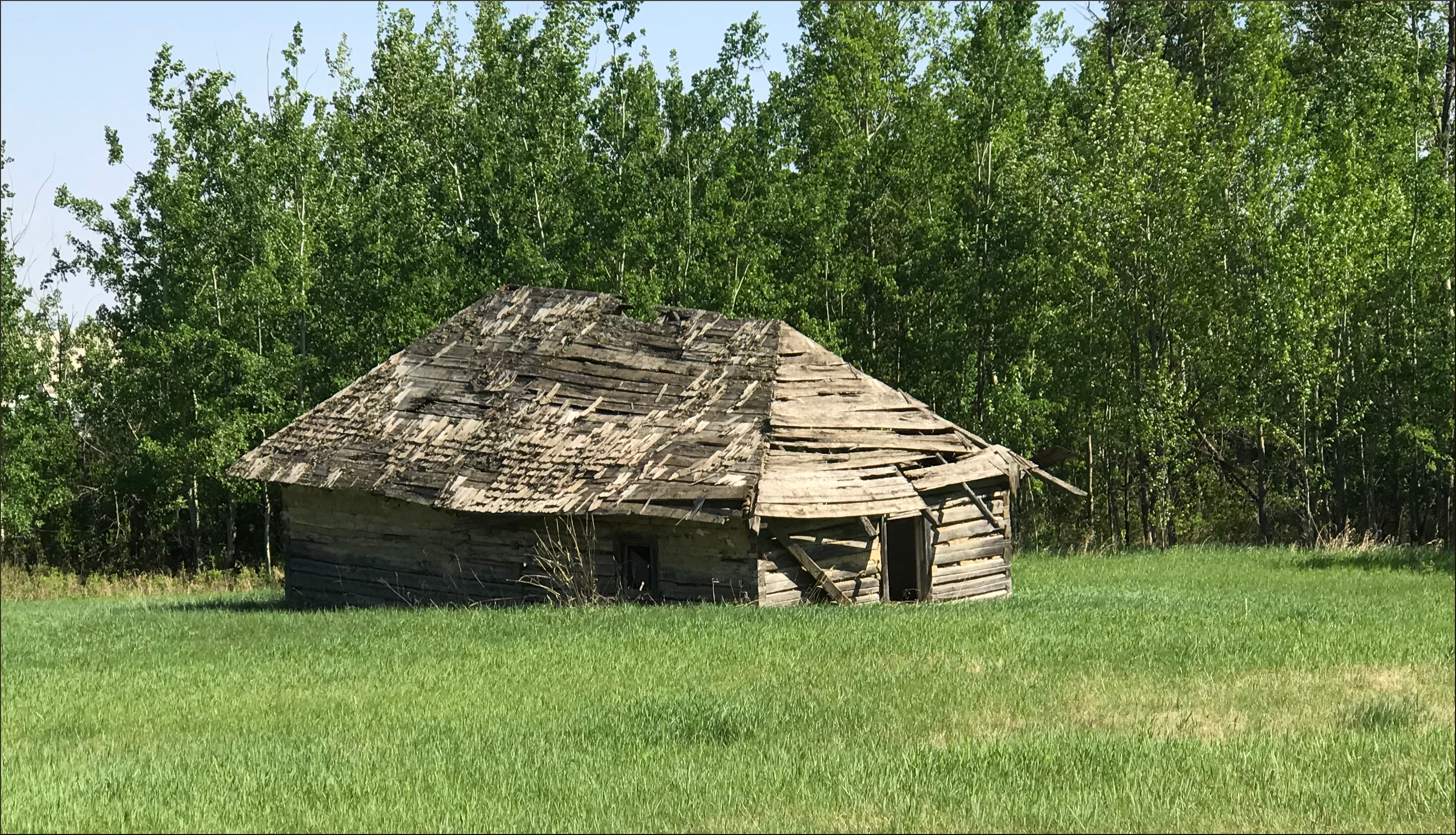
As you can discern from the name, a Ukrainian family from Toronto homesteaded here. I jest, they weren’t from Toronto, but they were Ukrainian. This was built in a style that was reminiscent of what had been used in Europe, with hipped roofs and plastered log walls. When the pamphlet was written, this structure was still in rather good shape, but, as you can see, the ensuing years have not been kind to it.


I should note that just before you get to this building (or perhaps it is best to say former building), you go over a bridge that crosses a creek.

After the Victoria Trail

Just after the aforementioned forlorn building, you arrive at the intersection of Victoria Trail with Highway 45. This is also close to Highway 830 and Highway 38. Any of these roads can be used to connect back to Edmonton, or wherever you may wish to go next.

In our case, that meant:

Highway 45 to Andrew,

Followed by Highway 855 to Mundare,

and finally Highway 16 back to Edmonton.


And here are some other travel accounts that you might like, on Amazon. 

===========================================================

On the Road with Bronco Billy


Sit back and go on a ten day trucking trip in a big rig, through western North America, from Alberta to Texas, and back again. Explore the countryside, learn some trucking lingo, and observe the shifting cultural norms across this great continent.

Amazon U.S.: http://www.amazon.com/gp/product/B00X2IRHSK

Amazon U.K.: http://www.amazon.co.uk/gp/product/B00X2IRHSK

Amazon Germany: http://www.amazon.de/gp/product/B00X2IRHSK

Amazon Canada: http://www.amazon.ca/gp/product/B00X2IRHSK


=======================================================

What follows is an account of a ten day journey through western North America during a working trip, delivering lumber from Edmonton Alberta to Dallas Texas, and returning with oilfield equipment. The writer had the opportunity to accompany a friend who is a professional truck driver, which he eagerly accepted. He works as a statistician for the University of Alberta, and therefore is generally confined to desk, chair, and computer. The chance to see the world from the cab of a truck, and be immersed in the truck driving culture was intriguing. In early May 1997 they hit the road.

Some time has passed since this journal was written and many things have changed since the late 1990’s. That renders the journey as not just a geographical one, but also a historical account, which I think only increases its interest.

We were fortunate to have an eventful trip - a mechanical breakdown, a near miss from a tornado, and a large-scale flood were among these events. But even without these turns of fate, the drama of the landscape, the close-up view of the trucking lifestyle, and the opportunity to observe the cultural habits of a wide swath of western North America would have been sufficient to fill up an interesting journal.

The travelogue is about 20,000 words, about 60 to 90 minutes of reading, at typical reading speeds.

==========================================

Driving North - On the Road to Northern Alberta and the Northwest Territories: A Driving Journal


Have you ever wondered about a road trip to the far north, north of the Sixtieth Parallel? Well, here is your chance to read about three road trips, through the Peace River country and the northern Rockies, all the way to the shores of Great Slave Lake, just south of the Arctic Circle.

Just $1.99 on Amazon, or free if you have Kindle Unlimited.


Amazon U.S.: https://www.amazon.com/dp/B074LZDQ9F

Amazon U.K: https://www.amazon.co.uk/dp/B074LZDQ9F

Amazon CA: https://www.amazon.ca/dp/B074LZDQ9F

Amazon Germany: https://www.amazon.de/dp/B074LZDQ9F

Amazon Japan: https://www.amazon.co.jp/dp/B074LZDQ9F

Amazon India: https://www.amazon.in/dp/B074LZDQ9F

Amazon Australia: https://www.amazon.com.au/dp/B074LZDQ9F


The highways in northern Alberta and the Northwest Territories give one the opportunity to drive pretty far north, without a lot of elaborate preparations and extreme expense. Starting from Edmonton, one can drive as far north as Yellowknife, NWT, without leaving the hardtop, so an average vehicle can do the trip. There are a reasonable number of fair sized towns along the way, so accommodations are not much of a problem, either. The same goes for food, gasoline and other essentials.

One can also link up with the Alaska Highway, and the Dempster Highway, and make it all the way to the Arctic Ocean. But that’s another story.

Trip number 1 involved driving north through Alberta, visiting several areas of interest along the way, then into the Northwest Territories, to Hay River on the southern shore of Great Slave Lake. The return trip featured a drive through the north-central foothills of the Rocky Mountains.

Trip number 2 was a combined air and car trip. We went to Yellowknife, Northwest Territories by airplane, then rented a car to explore much of the area of the north shore of Great Slave Lake.

Trip number 3 was a return to Hay River, with a different travelling companion. This allowed one to retrace steps, compare and contrast, and focus on some areas that we had not had time to explore in depth on trip number 1.


Tuesday, 28 July 2020

Has Covid-19 Become Less Deadly?


Has Covid-19 Become Less Deadly?

Historical Results from the 1918 Pandemic

Recently, the question has arisen about whether the Covid-19 disease (caused by the novel Corona Virus) has become less deadly, though perhaps more transmissible.  This is actually a distinct possibility, as this pattern has been observed in other pandemics throughout history.  Here is a quote from a very good book about the 1918 influenza pandemic, that notes how this phenomenon applied at that time:

“But the 1918 virus, like all influenza viruses, like all viruses that form mutant swarms, mutated rapidly. There is a mathematical concept called “reversion to the mean”; this states simply that an extreme event is likely to be followed by a less extreme event. This is not a law, only a probability. The 1918 virus stood at an extreme; any mutations were more likely to make it less lethal than more lethal. In general, that is what happened. So just as it seemed that the virus would bring civilization to its knees, would do what the plagues of the Middle Ages had done, would remake the world, the virus mutated toward its mean, toward the behavior of most influenza viruses. As time went on, it became less lethal.” (Barry, John M.. The Great Influenza (p. 371). Penguin Publishing Group. Kindle Edition.)

It is a matter of natural selection; a virus that is too deadly kills off its hosts (or generates behaviours such as social distancing among its hosts), which limits its reproduction.  Thus, there is a tendency for less virulent forms of the virus (created via random mutations) to survive and replicate themselves, eventually dominating the strains of virus among the host population.  So, the virus can both become less deadly, but more transmissible over time.  Eventually, it can become like the common cold – a successful nuicance, but not much of a threat.

Data Analysis of the 2020 Pandemic

The scatterplot graphs below show the death rates by country, expressed as deaths per case, for the early part of the pandemic (Feb-May3, 2020) and the latter part, so far (May4-July6).  The number of confirmed cases of Covid-19 are on the X-axis, while deaths are along the Y-axis, for about 175 countries.  Also included are the linear regression lines, giving the function relationship between cases and deaths, and the R-square coefficients, showing how close those relationships are to forming a straight line.

You will note that the first graph, that uses linear scales, is not all that compelling, even though the R-square of the lines are high (0.85 for the Feb-May3 period and 0.90 for the May4-July6 period).  That’s because of the huge differences in country populations and the different stages of the pandemic in various countries.  This has the effect of clustering the vast majority of points near the origin, thus obscuring the visual impression of the strength of the relationship.


Once the graph is re-scaled, by taking the (base 10) logarithms of the numbers of cases and deaths, as in the second chart, the relationship becomes much more evident.  Taking logarithms “spreads out” the data visually, so that the linear relationship is evident.  Note that the functional form of the relationship is the same as in the first graph, as is the R-square. 

You might notice that the points don’t seem to be evenly scatted around the regression line in this graph.  That’s a visual effect of taking logarithms, where distances on the graph are compressed as the numbers grow larger.  For example, the distance between the number 2 and 5 is the same as the distance between 5 and 8, in the linear scale (3).  But in the logarithmic scale the distance between 2 and 5 is .699-.301=.398, while the distance between 5 and 8 is .903-.699=.204.  So, that explains why the points on the logarithmic graph don’t seem to scatter “correctly” for a linear regression.

The important result is that the slope of the line for the data of the earlier period (0.065) is much steeper than it is for the later period (0.036).  Stating these results verbally, we can say that about 6.5% of covid-19 cases died in the earlier phase of the pandemic, compared to 3.6% in the later phase, based on this country level regression analysis.

Note that if one does a cumulative world percentage calculation the figures are 7.2% and 3.7%.  The difference is that the regression figures are essentially an unweighted average, while the second calculation is a weighted average.  But the country-level analysis is useful, as it shows that the percentage of cases that resulted in death were quite similar around the world, and that remained true of both the earlier and later periods.


An objection to this finding, is that countries are simply doing more testing as time goes on, so the cases found will tend to be less serious than previously, as testing is ramped up.  Thus the percentage of cases that result in deaths will go down, though the disease may actually be just as deadly as it was in the earlier period.

On way to test this hypothesis, is to look at the data by sub-sets of countries to see if there is any obvious pattern that arises.  It seems unlikely that testing would be ramped up all over the world at about the same rate, so if that was the cause of the falling death rates, we would expect variation around the world, in the rate at which death rates fell.  After all, not all countries have the technical capacity to ramp up testing substantially in a relatively short time frame.

The table below breaks out the country-level data by continent, hemisphere and latitude range, to look for such an effect.
Geographic Unit
 Feb-May3 Beta Coefficient
Feb-May3 Rsquare
 May4-July6 Beta Coefficient
May4-July6  RSquare
Early Beta/Later Beta
World
6.5%
0.8545
3.6%
0.9017
1.81
Africa
5.1%
0.6463
1.9%
0.8084
2.65
Asia
4.2%
0.8206
2.5%
0.9174
1.67
Australasia
1.3%
0.9998
0.8%
0.9621
1.63
Europe
11.2%
0.8162
2.3%
0.2669
4.78
Europe without Russia
11.7%
0.8598
10.7%
0.7457
1.09
North America
5.8%
0.9999
3.7%
0.9213
1.55
South America
6.0%
0.9043
3.8%
0.9899
1.56
North Hemisphere
6.5%
0.8533
3.5%
0.8591
1.86
South Hemisphere
5.9%
0.9095
3.8%
0.9854
1.57
High Latitude (40+)
11.1%
0.8171
2.4%
0.2633
4.66
High Latitude wo Russia
11.8%
0.8587
10.8%
0.7472
1.09
Mid Latitude (20-40)
5.7%
0.8486
4.0%
0.8968
1.42
Low Latitude (<20)
5.8%
0.9954
3.5%
0.9841
1.67

As you can see, in all cases the Beta Coeffiient (the pct of confirmed cases who died) was greater in the Feb-May3 period than it was in the later May4-July5 period.  In most cases it was about 1.4 to 1.8 times greater in the earlier period, which is what we would expect if the disease was growing less fatal overall, and if the less fatal strain was tending to dominate.

There is one major exception to this, which is Europe.  The difference in period death rates was much starker in the European case (4.78 times greater), and somewhat so in the African case (2.65 times greater) than in the rest of the world.  The high-latitude case is also much different, though that probably reflects the large number of European countries in that category.

We can uncover what “went wrong” with the regression for Europe, by looking at the country level data more carefully.  To do this, the data is shown on the linear scale, to see if there are some very influential outlier points, as below.  And, we see there are a couple of big outliers, namely the U.K. and the Russian Federation.


It looks as if the Russian Federation data is badly skewing the data here, so we will take that out and look at the resulting graph, which is also shown.  The data makes more sense now, with the resulting regression having an R-Square of 0.75 and the case-fatality rate now at 10.7%.  At this point in the pandemic, some European countries were undergoing a bad outbreak, with high fatality rates, while Russia not nearly so badly affected.  This also rectifies the anomalous result for the high latitude category in the latter time period.


So, according to this evidence, though there may be something to the higher testing hypothesis, it likely does not account for the entire drop in case-fatality rates. 

Another line of evidence can be deduced from the graph below.  This shows the number of tests versus the number of cases in Europe, during the two time periods.  In the first period, the number of tests compared to cases is approximately 11 to 1, while in the later period, this is about 44 to 1.  The testing rate increased by a factor of 4, while the case rate actually fell a bit.  One would expect a substanial increase in the number of cases in the later period, if enhanced testing was picking up a much higher proportion of mild cases in the latter period.


Remarks

Here are some concluding remarks:

  • The fatality rate, as measured by deaths per confirmed case fell from about 6.5% to about 3.6% from the Feb-May3 period to the May4-July6 period.
  • A drop in fatality rates was seen in most areas of the world, with the pandemic apparently about 1.5 to 2 times as deadly in the earlier period.
  • This is a phenomenon that is frequently seen in pandemics, though sometimes a second wave is actually deadlier than the first, as it was in 1918.  Eventually however, a virus will become less deadly, due to mutations and natural selection.
  • Though the drop in lethality might be partially explained by enhanced testing finding milder cases, this seems to only be able explain a relatively small part of the drop in lethality, at best.  Testing rates in Europe expanded by about a factor of 4, but case rates didn’t increase at all, between the two time periods.

There are, of course, cautions about any results of this sort, especially those that relate to sensitive subjects such as a pandemic.  Many people have doubts about the Covid-19 numbers from some countries, whether that be deaths, cases or tests.  No doubt there is some reason for concern, but the fact that the death rate fell in all areas of the world between the Feb-May3 and May4-July6 periods tends to support the idea that the drop in death rates is real, and not just an artifact of more extensive testing picking up less lethal cases (though there is likely some truth to that too).


Sources:
Some earlier Covid-19 blogs:

===========================================================


And, here’s a more pleasant travel story than anticipating the worldwide journey of a virus.

A Drive Across Newfoundland


Newfoundland, Canada’s most easterly province, is a region that is both fascinating in its unique culture and amazing in its vistas of stark beauty. The weather is often wild, with coastal regions known for steep cliffs and crashing waves (though tranquil beaches exist too). The inland areas are primarily Precambrian shield, dominated by forests, rivers, rock formations, and abundant wildlife. The province also features some of the Earth’s most remarkable geology, notably The Tablelands, where the mantle rocks of the Earth’s interior have been exposed at the surface, permitting one to explore an almost alien landscape, an opportunity available on only a few scattered regions of the planet.

The city of St. John’s is one of Canada’s most unique urban areas, with a population that maintains many old traditions and cultural aspects of the British Isles. That’s true of the rest of the province, as well, where the people are friendly and inclined to chat amiably with visitors. Plus, they talk with amusing accents and party hard, so what’s not to like?

This account focusses on a two-week road trip in October 2007, from St. John’s in the southeast, to L’Anse aux Meadows in the far northwest, the only known Viking settlement in North America. It also features a day hike visit to The Tablelands, a remarkable and majestic geological feature. Even those who don’t normally consider themselves very interested in geology will find themselves awe-struck by these other-worldly landscapes.

A Ride on the Kettle Valley Rail Trail: A Biking Journal Kindle Edition

by Dale Olausen (Author), Helena Puumala (Editor)
The Kettle Valley Rail Trail is one of the longest and most scenic biking and hiking trails in Canada. It covers a good stretch of the south-central interior of British Columbia, about 600 kilometers of scenic countryside. British Columbia is one of the most beautiful areas of Canada, which is itself a beautiful country, ideal for those who appreciate natural splendour and achievable adventure in the great outdoors.

The trail passes through a great variety of geographical and geological regions, from mountains to valleys, along scenic lakes and rivers, to dry near-desert condition grasslands. It often features towering canyons, spanned by a combination of high trestle bridges and long tunnels, as it passes through wild, unpopulated country. At other times, it remains quite low, in populated valleys, alongside spectacular water features such as beautiful Lake Okanagan, an area that is home to hundreds of vineyards, as well as other civilized comforts.

The trail is a nice test of one’s physical fitness, as well as one’s wits and adaptability, as much of it does travel through true wilderness. The views are spectacular, the wildlife is plentiful and the people are friendly. What more could one ask for?

What follows is a journal of two summers of adventure, biking most of the trail in the late 1990s. It is about 33,000 words in length (2 to 3 hours reading), and contains numerous photographs of the trail. There are also sections containing a brief history of the trail, geology, flora and fauna, and associated information.

After reading this account, you should have a good sense of whether the trail is right for you. If you do decide to ride the trail, it will be an experience you will never forget.

On the Road with Bronco Billy

Spring is on us now, and that brings on thoughts of ROAD TRIP.  Sure, it is still a bit early, but you can still start making plans for your next road trip with help of “On the Road with Bronco Billy”.  Sit back and go on a ten day trucking trip in a big rig, through western North America, from Alberta to Texas, and back again.  Explore the countryside, learn some trucking lingo, and observe the shifting cultural norms across this great continent.  Then, come spring, try it out for yourself.