Fort Assiniboine Road Trip (Oct 2024)
You can do this trip easily from Edmonton in a day (return). It is mostly farmland, with the highlight being a crossing of the Athabasca River on a ferry, followed by a visit to a provincial park near the river, that is noted for sand dunes. This trip was by myself and my son Scott.
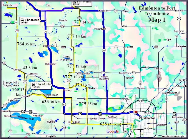
1) Edmonton to Intersection Hwys 628/779 (near Stony Plain), via Highway 628
-
This highway was mostly a fairly narrow two-lane road, that passes by the River Cree Resort and Casino (owned by a local native community), then by semi-rural farmland interspersed with acreage developments.
-
We have driven this route to get out of Edmonton (westward) on many occasions. The road varies from gravel to choppy pavement to new pavement. On the way out there are a lot of big power pylons along the road, as this route goes in the general direction of the Keephills generating station. There is also light industrial usage, as well as farms and acreage developments.
-
Along the way, there was a large group of crows and a few magpies, that were feasting on an animal corpse in a farmer’s field (the field had recently been harvested). Though they were going at it with great gusto, they were still at it when we passed this area on the way back, 6 or 7 hours later.
2) Intersection Hwys 628/779 (Stony Plain) to Intersection 779/37 (near Calahoo), via Highway 779
-
Traffic on this route was fairly brisk until reaching Calahoo, especially for the time of day (past rush hour).
-
There was a very long train that blocked traffic on Hwy 779, just as one was leaving Stony Plain. In fact, while train A was moving eastward, another train B came along, which was moving westward. The latter train B was primarily oil cars, while the much longer train A was primarily boxcars. Perhaps the newly opened oil pipeline heading for the west coast has diverted a lot of oil transport away from the train system.
-
Many of the train cars had that unreadable graffiti on them. While I am glad that it isn’t obscene or political (for the most part), I can’t understand why people create ‘signatures’ that aren’t legible. Is everyone ‘the artist formerly known as Prince’?
3) Intersection Hwys 37/779 (near Calahoo) to Intersection 779/777, via Highway 779
-
Traffic was fairly light on this stretch of highway.
-
It was just a short connector route, tying togehter 779 and 777.
4) Intersection Hwys 779/777 to Intersection 777/18, via Highway 777
-
There is a short jog to the east, where 777 meets 642. The turnoff to pick up 777 north was a bit tricky to find, as it wasn’t signed very well. In addition, 777 north at this point was gravel, which was a bit unexpected.
-
We first over-drove the turnoff, but fairly quickly turned back and picked up the route (signage was better going the other way). Fortunately the traffic was very light, so the U-turn wasn’t a problem (there are many little entrance-ways to farmer’s fields which are handy for these manoeuvres).
-
This two-lane gravel stretches were rather wide and level. They also seemed to be graded quite regularly, so they made for decent driving conditions.
-
This was primarily farm country. Since it was late in the fall, it wasn’t very colourful, as most crops had been harvested.
-
This was especially true of hay, as there were copious amounts of hay bales in evidence. Sometimes these were still in the fields, sometimes there were walls of hay bales stacked up.
5) Intersection Hwy 777/18 to Intersection 18/776, via Hwy 18
-
The route then picks up Highway 18 west for a short stretch, before intersecting with Highway 776.
-
The most notable feature of this short stretch (about 5 km) was a crossing of the Pembina River. It is a tributary river to the Athabasca River, which this route will also cross. Both of those rivers begin in the Rocky Mountains. Eventually, these waters flow all the way to the Arctic Ocean, via the Mackenzie River. The Pembina and Athabasca rivers are historically connected to the fur trade era and later to the agricultural settlement of the Peace River region. There are many very scenic views of this river, though this isn’t really one of them (note: it is taken from Google Maps). :)
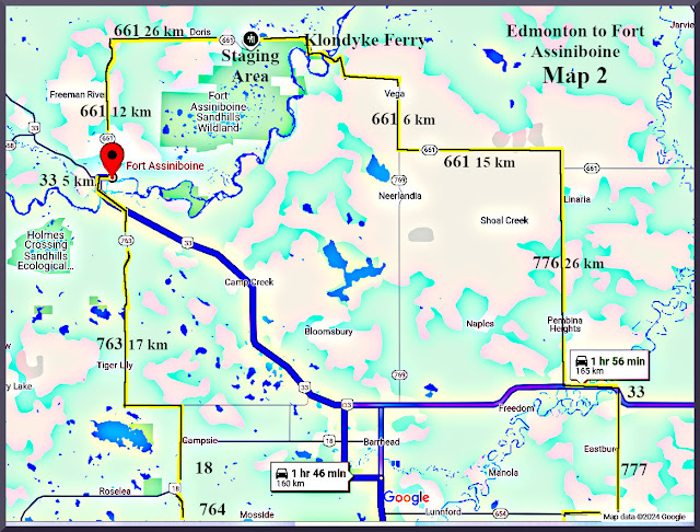
6) Intersection Hwy 18/776 to Intersection 776/661, via Hwy 776
- The route runs north on 776 for about 25 km, where it intersects 661.
-
This stretch had few cars and was pleasant driving.
-
This area tends to be pretty darn flat.
7) Intersection 776/661 to Intersection 661/33 (near Fort Assiniboine), via Hwy 661
-
This was the mid-point and highlight of the trip, as it included two interesting features.
-
To begin with, Hwy 661 was a fairly flat paved road. After a bit, though, it made a few turns and then descended into a gravel road. There were signs for the Klondyke Ferry, which crosses the Athabasca River.
-
At first, we missed the turnoff to this ferry, as the signage was a bit spotty on this section.
-
After heading down Range Road 40 for a minute or two, we turned back realizing this ferry was actually how we were to cross the Athabasca River. RR 40 dead-ended in less than a km, so there wasn’t much choice in the matter.
-
We hadn’t actually known that there was a ferry crossing on this trip, but it was an interesting surprise. There are only a few ferries still operating in Alberta – I hadn’t heard of this one, which is rather off the beaten track.
-
The area around the ferry had some residences as well. It was gravel down to the ferry, and some rather steep hills. Given the conditions, these were no problem, though it would have been tricky in rainy or snowy conditions. I don’t believe the ferry operates in the winter, so I suppose you must go along some alternate route at that time of year.
-
It looks like the province keeps the ferry in operation at least partly as a historical/tourism feature. It goes back to the early 1930s.
-
It only holds a few vehicles at a time, perhaps 4 smaller cars could fit in, less for trucks. There is no charge and the ferryman seems to ply a steady trade, as long as there are some vehicles to take across.
-
The ferry is towed by guy-lines above the river, rather than being self-propelled. There is a prominent warning that the ferry won’t be used if there is a prospect of an electrical storm, so obviously the power-lines are a concern if lightening is possible.
-
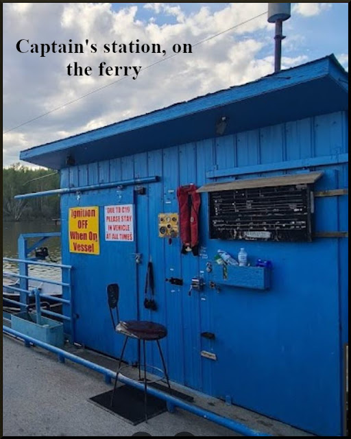
The historical nature of the operation is maintained by a sort of abacus-type counter system, that is used to count the number of vehicles making the trip on that day. There are separate sliders for cars, trucks, motorcycles and foot traffic.
-
The area also has a park, where you can camp for $12 per night.
-
We got on the ferry pretty quickly, as there was little traffic at this time of year, so didn’t have to wait. However, it looks like traffic is considerably more busy in the summer, judging by the photos on Google maps.
-
The trip on the water, probably took less than five minutes.
-
All in all, it was a bit of unexpected fun.
-
Once across the river, we were into the Fort Assiniboine Sandhills Wildlife Provincial Park.
-
This area also had a winding gravel road, gravel and sand, actually.
-
One could see areas where people had taken trail-bikes or snowmobiles up the sides of the hills along the roadway. Evidently, this is a popular place for off-road recreation. That includes horses.
-
We decided to have our picnic lunch at the Central Staging Area. That was about 3 km into the park on a narrow winding sand and gravel road, with plenty of changes in elevation. I think our taste in jackets is ok.
-
This was rather fun to drive, though it would have been rather chancy in wet conditions.
-
We actually went up the road further from the turnoff to the Staging Area, out of curiosity. But after a few km, we turned back and went to the staging area. Again, that would have been a rather tricky maneuver on this narrow road, were it in the wet season.
-
There was a nice camping area there, with toilets, campsites and picnic tables. We were the only people there, which is hardly surprising, given the time of year. That said, we did see one other park on the road in to the staging area.
-
There were plenty of signs, warning people of the possibility of bear encounters. That didn’t happen to us, of course. We had a pleasant meal, with nothing but the moaning of the wind in the trees and the flight of some birds to accompany us.
-
After that, it was back onto Highway 661, which became pavement again, once we left the park. It was recently paved, so very smooth.
-
My son Scott took over the driving duties at this time.
-
Once out of the vicinity of the river valley, the ground was flat again.
-
Given that it was late October, most of the deciduous trees (poplars and birch) had already dropped their leaves. It was not the most scenic time of year, but the day was quite warm (about 10 degrees Celsius), with a nice mix of sun and cloud.
-
Some grasses were still green. The main sights were farmer’s fields and trees that had been planted for wind breaks.
8) Intersection 661/33 to Intersection 33/763, via Highway 33
-
The route had a short section on Highway 33, connecting 661 and 763, which would take us back south.
-
We got gas at a station in Fort Assiniboine. Even out here, the gas stations were now staffed by FTWs. This had become a big political issue by this time around the country. It seemed as if businesses were ignoring local labour markets in favour of foreign temporary workers everywhere, even in this relatively northern rural area.
-
We crossed the Athabasca River again at this point. The crossing was very different from the Klondyke Ferry.
9) Intersection 33/763 to Intersection 763/764, via Highway 763
-
We were basically back in farming country for a lot of the trip back to Edmonton.
-
There were many cattle in the fields. In one area they were mostly dark coloured beef cattle.
-
A little ways farther on were cattle that looked more like the black and white Jersey variety. I gather that these are mostly dairy cattle.
-
More cows, now brown – I don’t know how, perhaps one could ask one of these cows.
10) Intersection 763/764 to Intersection 764/43, via Highway 764
-
Further south, the land became more rolling. It was still dominated by farming. As on the way up, there were great numbers of hay bales, stacked in all sorts of interesting ways.
-
There were also fields with slash piles (trees that had been cut down). I guess farmers were becoming optimistic and increasing their cultivated land.
-
A low bridge crossing, near Cherhill. This was over a waterway called Deep Creek, which eventually flows into the Athabasca River.
-
Some flecks of snow for a few minutes, but it didn’t turn into anything.
11) Intersection 764/43 to Intersection 43/765, via Highway 43
-
A short connector between 764 and 765.
12) Intersection 43/765 to Intersection 765/633, via Highway 765
-
In a couple locations along this route were some fair sized flocks of birds. They were white, of average size, I am not sure of the species.
-
We also had a couple of deer run across the road and jump a fence. They were pretty close to the car, but no real danger of hitting them. It looked like it might have been a doe and a fawn.
-
I should not that on the way up, there was a partridge (or similar book) crossing the road. We came rather close to hitting it, but it evaded in time.
-
Similarly, a black cat crossed the road in front of us. It was getting close to Halloween, so I suppose that was appropriate.
13) Intersection 765/633 to Intersection 633/Range Road 20, Highway 633
-
Scott was getting tired, so I took over the driving again.
-
Another flock of those birds, wish I knew what they were.
14) Intersection 633/Range Road 20 to Intersection RR20/628 (near Spring Lake), via RR20
-
This is a pleasant stretch of road, passing by hobby farms and such, and eventually through the lakeside community of Spring Lake.
15) Intersection RR 20/628 (near Spring Lake) to Edmonton, via Highway 628
-
The crows and magpies were still feasting on the corpse of some large animal, that had probably been hit by a car, then wandered into the field along the road to die.
-
We, on the other hand, made it back to the city safely. Traffic was surprisingly light coming into the city, but it looked like a disaster leaving the city.
-
We stopped at Peter’s burger place for supper, to share with my wife/his mother.
-
And that was that.


No comments:
Post a Comment